Taking 3D Modeling to New Heights (by Jared Divido)

For the past year and a half, I have been working on an ongoing thesis project that seeks to test the feasibility of 3D laser scanning in a zooarchaeological context.  I have been using the NextEngine HD Scanner and the MakerBot 3D Digitizer to scan bones from various species of waterfowl (Figure 1). You can read more about my project here:

Left: humerus of a Black Duck (Anas rubripes). Right: using the 3D scanner and imaging software.

Over the summer, I had the opportunity to work with Dr. Benjamin Ford to test 3D technologies on a much larger scale.  In the process, I’ve acquired new knowledge about 3D techniques, and their response to different environments.  The goal of this mini project was to create miniature 3D replicas of two buildings on the Indiana University of Pennsylvania’s campus, which included McElhaney Hall and Sutton Hall.  After my first brain storming session, I thought that photogrammetry would be the best technique to construct the 3D models.  Photogrammetry is a 3D modeling method in which you take multiple overlapping images around an object of interest.  The researcher then imports the photographs into photogrammetry software, and the software uses references points from the photos to build a “mesh cloud” of the object.

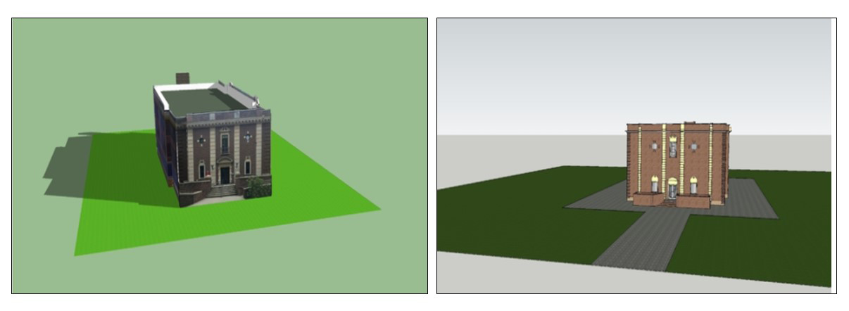
After multiple attempts of using this technique, I quickly discovered that it would not work with all of the beautiful foliage that encompasses the buildings. The shifting background lighting in the sky and the height of the building features also created additional issues when it came to stitching all of the images together.  The resulting photogrammetry model of McElhaney (below) turned out slightly wavy and distorted in sections where tree limbs were obstructing features of the building.  The use of drone technology may have alleviated some of these problems since a drone’s camera can capture detail that cannot be photographed from the ground.  However, potential safety issues prohibit the use of drone technology near academic buildings.  So… I had to get creative and use of a mixture of the photographs and pre-existing satellite imagery from Google Maps (2017) to construct the building models.  I was able to pull the map data into a 3D modeling program called SketchUp, and I used the satellite maps to obtain reference points for the scale and size of the buildings.  From there, I imported the photographs and manually overlay the architectural features (e.g., stairs, windows, and porches) of the buildings using the build tools in SketchUp.  A comparison between the photogrammetry model and manually created SketchUP model are linked below.  The rationale for manually adding in architectural features was to emphasize them for 3D printing

Photogrammetry (left) and SketchUP Build (right) rending of McElhaney Hall.

In the end, the 3D models of the buildings may not have turned out to be exact replicas of their original forms due to some of the issues mentioned above.  However, this project has taught me a lot about the potential advantages and disadvantages of using 3D techniques at larger scales and changing environments.  The resulting models are optimized for 3D printing, which means some of the textural features had to be simplified or eliminated to make the models more structurally sound and printer friendly.  At present, I am using the MakerBot 3D Replicator to “build” miniature tabletop replicas of the buildings.


Visit the IUP Anthropology Department

My Research Experience for Summer Scholars by Harley Burgis

This summer I entered the Research Experience for Summer Scholars (RESS) program, so I could study zooarchaeology more intensively. The program and the research led to a great experience for me to have during my undergraduate years. Generally, I spent most of my time conducting my research, which was faunal analysis from previous excavations at the Johnston site (36IN0002). For my project, I identified and analyzed faunal remains from the western section of the site, that were recovered during the 2012 excavations. Specifically, I identified bones to their elements, genus, and species when applicable. This project has really been able to help me work on my identification skills and to solidify my desire to study zooarchaeology.

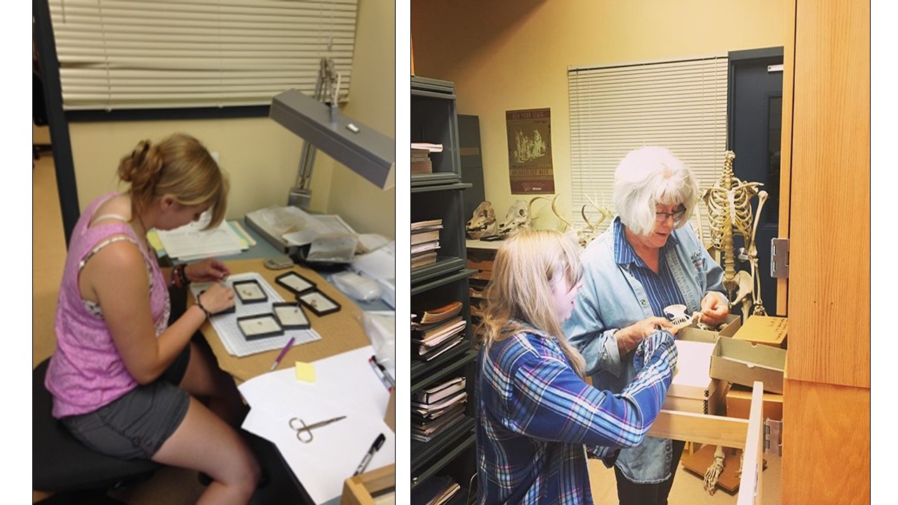
Working in the faunal lab in McElhaney Hall

Besides conducting research, I participated is RESS events, which included workshops, presentations, and social events. The social events were fun, because it allowed me the chance to spend time with like-minded people in different fields, which is what this whole program was about. This program allowed me the opportunity to meet other student researchers, as well as gain necessary skills for conducting research. I really enjoyed this program and I would recommend it for others who wish to conduct summer research here at IUP.

faunal material from the Johnston Site excavations.


Visit the IUP Anthropology Department

Update from the PHAST crew (by Ross Owen)

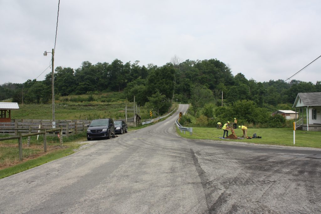
Each summer, PennDOT hires a field crew to gain experience running archaeological surveys as part of the environmental clearance for PA’s multitude of transportation-related construction projects.  PHAST (PennDOT’s Highway Archaeological Survey Team) is supervised by an IUP graduate student enrolled in the Applied Archaeology MA program – that’s me. This year’s PHAST crew is comprised of three IUP grad students: Genevieve Everett, Sami Taylor, and Zaakiyah Cua. The intricacies of completing archaeological field work in a cultural resource management (CRM) setting can be difficult to fully grasp in a classroom setting, and PHAST allows students to gain valuable working experience and hone their field skills.

Covering the entire state of Pennsylvania, the PHAST crew has a wide variety of projects. The project list and schedule are in a constant state of flux, and the unpredictability of CRM work is readily apparent. Jobs scheduled for a whole week of field work may be completed ahead of schedule if no archaeological sites are found, or if the project area has already been disturbed by modern activity. Similarly, jobs scheduled for a day of work may stretch on for weeks if a site is encountered, or if testing goes especially deep (our .57-cm diameter shovel test occasionally reach a depth of 1-meter before we encounter an appropriate stopping point). CRM work forces you to constantly reassess the situation based on new information, from the planning stages to the actual field work.

The PHAST crew hard at work

This summer started off with a bang. We encountered a prehistoric lithic reduction site on our first project, located in Allegheny County near Chartiers Creek. Within a single 1m x 1m test unit, we recovered over 500 lithic artifacts – mostly flaking debris and cores associated with the production of stone tools. Encountering sites is exciting, but not a daily occurrence in CRM archaeology, as many of our projects since then attest to. Of the 11 projects we’ve completed field work for, only 3 contained sites.

As busy as we’ve been traveling across the state from the Southwestern corner near Prosperity, PA to State College in the Center, and down to Muddy Creek Forks in Southern York County, it’s no wonder the summer is flying by. Helping out at the Hatch Site (see July 3 blog) for three weeks was the longest we’ve been in the same spot, and gave us a rare CRM opportunity to work on a full-scale data recovery project at a known archaeological site.

The PHAST crew at the Hatch site (from left to right: Zaakiyah, Sami, and Gen)

Nearing our final month of field work we have 4 projects that need to be completed. Two consist of the standard survey method of shovel testing the project areas for bridge replacements in Jefferson and Washington Counties, while the other two are Ground-Penetrating Radar (GPR) surveys to try and locate a French-Indian War Fort in Lehigh County and out-buildings associated with one of the homes in Old Economy Village. There’s always the potential that a few small projects will pop-up before the end of August when classes start and the PHAST crew moves indoors to focus on the lab work, curation, and report writing.  The crew will be employed by PennDOT through the end of October, but I’ll remain the PHAST director until May of 2019 when I graduate – stay tuned for more updates!

Visit the IUP Anthropology Department

The Juniata College Archaeology Field School (by Chris Swisher)

After classes ended this spring, I had the opportunity and privilege to help supervise the Juniata College Archaeological Field School alongside my former classmate Kate Peresolak and under the direction of Dr. Jonathan Burns of Juniata College. Located in State College, Pennsylvania, the project was a unique experience for a field school because it was a real-world Phase III archaeological project serving as a mitigation for a bike path that will soon have an adverse effect on the site. The James W. Hatch Site, named for the late Penn State University professor, is a lithic reduction site. In other words, this location served as a place where Native Americans would bring nodules of local lithic materials to be worked into stone tools. In this case, the local materials were being quarried from a source of jasper known as the Tudek Quarry at the top of the hill from the Hatch Site.

This site was first discovered during a Phase I and subsequent Phase II project in the summer of 2015 by the PennDOT Highway Archaeological Survey Team (PHAST). This work determined that the Hatch Site was eligible for the National Register of Historic Places and the threat of destruction by the bike path required that some sort of mitigation of the site be conducted. In the spirit of creative mitigation, it was decided that an excellent way to include the public, educate students, and of course save money was to make the project a field school for undergraduate students. A total of 11 students participated in the field school from Penn State University, Juniata College, and Virginia Commonwealth University. Also in the mix were a couple of hired field technicians, the PHAST crew (which consists of four IUP grad students), and several hard-working volunteers throughout the four-week excavation.

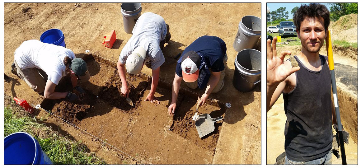
Left to Right: Kristen, Brendan and I working in the offset test units that would later yield the slag buried deep in the buried plow zone and (far right) VCU student Luciano with the Kirk corner-notched point

We began this project by mechanically stripping the modern plow zone in two 10x10m blocks. Within these blocks, we used a total station to set up two 5x5m blocks to be excavated. The original plan was to excavate 1x1m test units within the blocks divided into 50x50cm quadrants and each screened in 10cm levels. We did this for about a day or two until we found some large chunks of slag at the bottom of the stratum previously thought to be undisturbed. Upon this discovery that the stratum was actually an older plow zone, our strategy changed to excavating the test units by stratum rather than excavating in 10cm levels by quadrants. Once we got through the deepest plow zone we returned to our original strategy in the clay beneath.  Unfortunately, no diagnostic artifacts were found in the intact stratum, but we did find some projectile points in the old plow zone, including a Kirk corner-notched point! This gave the site an Early-Middle Archaic occupation and made the students more excited and motivated to keep up their hard work in the unpredictable weather conditions of central Pennsylvania. We also collected a few charcoal samples from features in the clay that will be radiocarbon-dated.

Left: Bird’s eye view of Blocks A and B with the drone. Right: the crew hard at work in the last week of excavation

This project was great for many reasons, but I will only list three main points here. First, it allowed students an opportunity to work on a real CRM project with a deadline. Second, we all had the opportunity to learn more about using a total station and how much time it saves. Third, the Hatch Site is one of many sites associated with my Master’s thesis, which involves synthesizing data from over 40 nearby archaeological sites unofficially collectively known as the Houserville Archaeological District. The result of my thesis will include an official nomination of the district to the National Register of Historic Places on the basis of its significance as a stone tool production locale in relation to the Tudek Quarry. The field school was an incredible way to get the public involved and teach students while conducting a necessary archaeological endeavor to collect data that would otherwise be lost forever. For more information and photos from the project check out the Juniata College Archaeology Facebook page and The Eclectic Bear blog by PennDOT archaeologist Joe Baker. A big thanks to all of the great students, crew, and volunteers who helped us move so much dirt, and to the many visitors we had over the four-week field school.

Group photo of the students and crew taken in Block A


IUP Anthropology Department

Another Fun SPA field trip (by Sarah Neusius)

For the third year in a row Dr. Phil and I have just had a great time participating in the Society for Pennsylvania Archaeology (SPA) field trip.  This annual road trip over a long weekend in early June is an opportunity for SPA members and their guests to see some of the fabulous archaeology excavations, sites, and museums within driving distance of Pennsylvania, while also getting to know other professional and avocational archaeologists from across the state.  Dr. John Nass of California University of Pennsylvania and I have done the planning and leading of each field trip, while Dr. Phil has been one of the van drivers.  This year we loaded up two vans and headed north to New York state to visit several museums and their archaeological collections. There was an emphasis on the Iroquois Indian nations of New York although we also learned about other archaeological and anthropological topics and research as well as saw some fabulous contemporary Native American art.

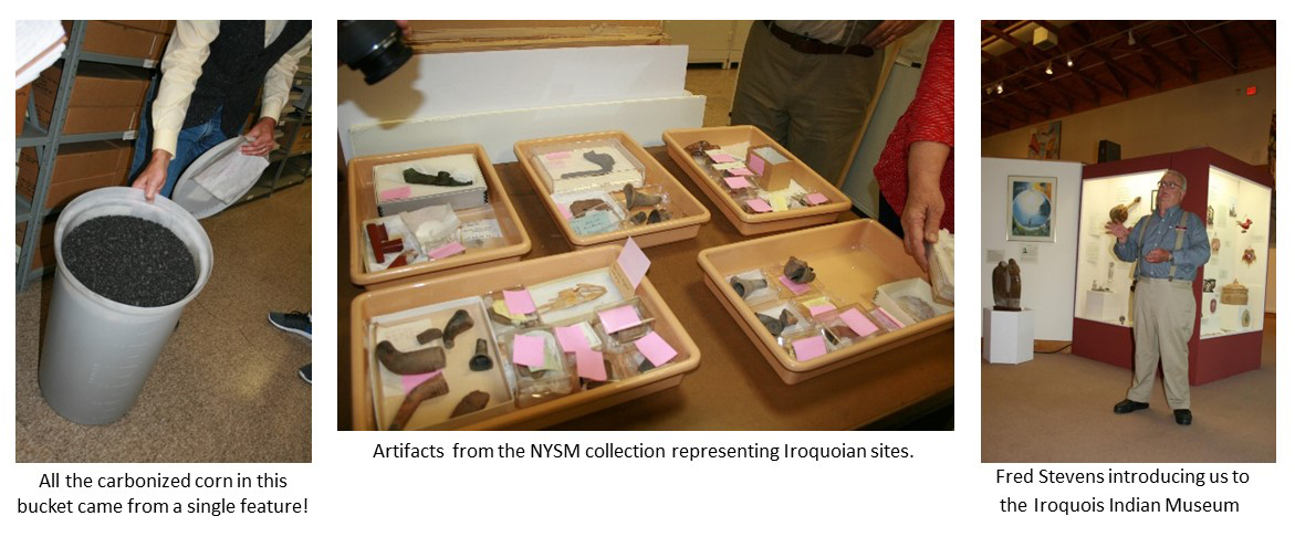
This year’s field trip started with an orientation and social time at our hotel in Binghamton, NY on the evening of Thursday, June 8.  Early Friday morning, June 9, we headed for Albany and the New York State Museum.  This is a museum I feel like I know because of research collaborations, especially the Ripley Archaeological Project, which was an IUP/NYSM project in the 1980s and 1990s.  Dr. Phil and I have been to NYSM many times for research purposes and visited the exhibitions several times.  Nevertheless, the tour organized for our SPA group by Dr. John Hart, Director, Research and Collections Division, gave us a much better sense of the vast collections held by the museum as well as of the variety of archaeological research going on there today.  The NYSM holds more than 16 million objects, specimens and artifacts and its research staff is active in the areas of archaeology, ethnology, paleontology, geology, botany, and history.  On this trip, we were privileged to see specimens and artifacts and hear about research on Paleoindians in New York State, on Iroquoian and Algonquian groups, on historical archaeology done in New York City, on the Albany Almshouse cemetery including the facial reconstructions done for skeletons, and more. We saw a great many really cool artifacts as well as some of Louis Henry Morgan’s ethnological collection, but my favorite thing might have been the huge quantity of maize kernels recovered from a single feature (see photo below) because it really underscores how central maize must have been in people’s diets in Late Pre-Columbian times. The only downside of our trip to the NYSM was that the Research and Collections staff gave us such an interesting and thorough tour that there was limited time to see the exhibits.  A more complete viewing of these will have to wait for another visit to this great museum!

After NYSM we went to the much smaller Iroquois Indian Museum in Howes Cave, New York, a private non-profit educational institution that promotes understanding of Iroquois culture.  It was started by an avocational archaeologist and has large archaeological collections, but it also displays a comprehensive collection of contemporary Native art, a children’s area featuring the Iroquois Creation story, and nature trails, which we did not attempt.  We did, however, get an introduction to the museum from their Archaeology Department head, Fred Stevens, who happens to be a long-time SPA member.

Friday evening we stayed in Schoharie, NY and had an thought provoking lecture on New York State archaeology and the limitations of the culture history approach by Dr. Hart of NYSM. The second day of our fieldtrip, Saturday, June 10, was a little less hectic although we did a lot of driving across much of New York State from Schoharie to Rochester, NY.  We did break the trip with a stop for a picnic lunch and a wine tasting at a winery in Seneca Falls, but before mid-afternoon we arrived at Ganondagan State Historic site and the Seneca Arts and Culture Center in Victor, NY.  This museum is at the site of one of the last large settlements of the Seneca, which was burned by the French early in the historical period.  Here we were given a tour by a young Mohawk interpreter of the newly built center which has fabulous exhibits about the site and traditional Seneca culture, before we were taken to tour the bark longhouse reconstructed on this site.  This is one of the best longhouse reconstructions I have seen with the interior as well as the exterior creating a real sense of these multifamily structures.  Saturday evening in our hotel in Rochester, we had an eye-opening talk by Jay Toth, archaeologist for the Seneca Nation of Indians, about recognizing past cultural landscapes through the plants encountered while surveying.

Sunday we wrapped up our trip with a visit to the Rochester Museum and Science Center (RMSC), another New York Museum with extensive Iroquoian collections. Unfortunately, the museum was experiencing a serious water main break when we arrived, and was in the process of closing.  However, our tour went forward in abbreviated form, and we were very ably led by George Hamell, a noted Iroquoian scholar.  George took us through the exhibits of the Rock Foundation collections displayed at Rochester and into some of the laboratory and collection space. Here too we saw fabulous collections representing early archaeological and ethnological acquisitions.  George also shared with us the Rock Foundation’s position that it does not have to comply with NAGPRA because it is a private, non-profit entity. Some of the objects they hold certainly are sacred objects and objects of national patrimony.  Though technically correct, there are ethical issues related to cultural sensitivity posed by our even being able to view these items, and we had some discussion about this aspect of our visit including that we should be mindful of the privilege we were granted.

By the time we finished our tour, we were the only visitors remaining and even the lights were shutting down; it was actually slightly spooky.  We had a quick picnic lunch in the cafeteria area and left the museum to struggle with its water issues as we headed home to PA. As you can tell, like each previous field trip we have done with the SPA, this year’s trip was full of chances to see and hear about lots of cool archaeology and artifacts as well as to learn from scholar experts and think about topics relevant to archaeology, anthropology, history, and science.  The part that is harder to convey is the fun and camaraderie that developed within the group.  There really is nothing like a road trip with other people interested in similar things, especially when they are archaeologists!  So we recommend that you keep your eyes open for next year’s SPA trip – destination to be determined.  Even if this is not possible, keep in mind that the museums we went to are great places to visit individually as well, so add them to your itinerary when you are in New York State.

IUP Department of Anthropology

My thesis fieldwork in Cyprus (by Sarah Henley)

This past May, I traveled to Cyprus to conduct my Masters thesis research. The purpose of my research is to use portable X-Ray Fluorescence (pXRF) analyze the elemental composition of Roman and Late Roman Period (30 B.C. to A.D. 614) Cypriot Red Slip ware (CRS) sherds, which basically provides a chemical “fingerprint” for sherds made from different clay sources.  My original goal was to compare my results to naturally-occurring clay bed samples in order to investigate their origin of manufacture, as well as regional trade patterns across Cyprus and parts of neighboring Turkey.

I traveled with Dr. Robert S. Moore from the IUP History department, and Dr. William R. Caraher from the University of North Dakota History department. We spent the first night in Larnaca, Cyprus, which is located in Larnaca Bay on the southeastern part of the island. Larnaca is a somewhat noisy city, with an oceanfront full of restaurants, an ancient fort at one end, and a marina on the other. There is also a beautiful church located down the road from the fort. Throughout the city there are various types of architecture, which gives the city character. As you make your way down small alleys you can find shops and more restaurants. The beach was also nice, but not as beautiful as other places I have seen in the Mediterranean.

The next day, we traveled to Polis, which is located on the western side of the island, and to give you an idea of the island’s size it took about 3 hours to get there from Larnaca. The inner terrain of Cyprus is beautiful with the Troodos Mountains, and the southwestern coast, which both reminded me of Greece. Polis was a nice small town, and much quieter then Larnaca.  The next 4 days we worked in a small, fairly dirty, basement where all the ceramic artifacts were curated. The first day I spent running tests with CRS body sherds to figure out how to go about collecting my data. I had not anticipated for each ceramic sherd to have concretion, which are limestone deposits that accumulate on artifacts that have been in the ground for long periods of time. Concretion can only be completely removed by acid, which takes a great amount of time to remove.  The next 3 days I spent collecting my data. I tried to test areas on each sherd that had the least amount of concretion.  On May 20th we returned to Larnaca. The last 4 days we worked in a warehouse, which was cleaner then the curation building in Polis. The sherds were in bags, which were in crates that were marked by excavation unit(s). Dr. Moore had e-mailed me a list of the CRS sherds, and I pulled them from the crates, and bags. Fortunately, these sherds had less concretion on them because they were surface finds.

XRF unit (left) and example of concretion on an CRS sherd (right)

A professor from Messiah College’s history department, Dr. David K. Pettegrew, an associate of Dr. Moore and Dr. Caraher’s, brought a group of undergraduate students to Cyprus. On my last day I had the opportunity to talk to the students about pXRF and my thesis. While in Cyprus Dr. Moore showed me the sites in which the sherds I tested came from. In Polis the sherds were excavated from the porch of a Christian basilica dating to the 6th/7th century A.D. In Larnaca the sherds were collected from a Roman Period site that used to be a major southern port town.  Overall, I had a  good experience; the only down side was I was not able to collect clay bed samples as originally planned. Later in June I will be meeting with the Applied Research Lab people at IUP, who will help me to statistically statistically analyze my data.

IUP Department of Anthropology

IUP Archaeologists March for Science

By: Genevieve Everett

Last Saturday, Earth Day, Dr. Sarah, Danielle, Kate, Jared, Heather, Sami and I woke up in the early morning hours to hit the road for the March for Science in Washington DC. The weather forecast was calling for rain all day, so we came mostly prepared for that, with our signs of support in tow. We arrived at the Metro Station around 9 am, still feeling groggy from our early start, but energized to join the thousands of people coming to the march for science.

Bill Nye!

After a short Metro ride, we were heading toward the National Monument where we stood in line looking on at the beautiful new National Museum of African American History and Culture . We were surrounded signs that read “Science not Silence” and people in lab coats. Waiting in line to get into the rally, the rain began with a light drizzle. Inside the gates we made our way through the crowds to stand in front of a giant jumbo-tron to watch the many speeches that were planned for the day. Different scientists or supporters of science, young and old came to speak about the importance of science, and how it has impacted their lives and the lives of others. Sadly, no archaeologists spoke, but it was inspirational nonetheless. And finally….BILL NYE THE SCIENCE GUY came out to end the rally. The rain began to pick up, but the moment we had all been waiting for had finally come! He stood at the podium speaking about the need to encourage lawmakers to take the sciences seriously for the well being of all. As a kid I idolized Bill Nye, and now that I’ve grown up I still see the same passion that came through my television set, and it makes me feel a glimmer of hope for the future of science and our planet, because as many signs around us said, “THERE IS NO PLANET B”.

With time to kill, we stopped and got some lunch at a little deli where we had a chance to “dry” off a bit. With our stomachs full, we headed toward the front of the march. Waiting on the side of the road we watched as Bill Nye and a long line of smiling faces proudly held a “March for Science” banner. We joined the masses of people, holding our own signs high. We heard the occasional call and response chant of,  “WHAT DO WE WANT? EVIDENCE BASED SCIENCE. WHEN DO WE WANT IT? AFTER PEER REVIEW!”. There was an overall feeling of connectedness, and it was an awesome feeling. The march ended at Union Square across from the Capitol Building where everyone dispersed to go back to their normal lives.

A week later I am sitting at my computer thinking how lucky I am to be able to stand up for what I believe in. Archaeology may not be the first thing people think of when they think of science, but we are scientists through and through. With the treat to cultural resources in this country, we must work to preserve and protect them, because they are non-renewable resources, just like our precious planet. Although last Saturday was a long day after being up early and getting soaked, it was completely worth it in the name of science!

IUP Department of Anthropology

American Grad Students in Canada: Our trip to the SAA, eh.

By: Matthew Bjorkman and Britney Elsbury-Orris

Hello! We are Matthew Bjorkman and Britney Elsbury-Orris, and this is our first contribution to Trowels and Tribulations, and honestly…what took so long! We are both first-year graduate students in the Applied Archaeology program, and we have had the pleasure of attending way too many conferences this semester. At the end of the fall semester, while we were riding the high of turning in our final assignment, we volunteered to become members of the IUP Ethics Bowl team. While we did not fully understand the time commitment we had just signed up for (we blame the lack of sleep), we knew that it would give us an opportunity to flex our ethics muscles in competition at the 82nd annual meeting of the Society for American Archaeology in Vancouver, British Columbia.

Beautiful view outside the Convention Center

Despite being poor college students once again , we were able to book our trip. Departing from Pittsburgh at way-to-early in the morning, we had a short layover in the San Francisco airport before finally arriving in Vancouver the day before the conference (Trip bonus: we flew on United on both legs of our trip and neither of us was asked to give up our seat or got stung by a scorpion). After wandering aimlessly in the city for an hour, we arrived at our hotel, Hotel Blu. The hotel was fantastic, far too classy for this duo. Our first day, the day before the start of the conference, was spent figuring out how to get our phones to work in a foreign land, and meeting up with Ethics Bowl teammates and other IUP students. We got together and searched for a spot to grab dinner. After searching for a restaurant that Matt swears was selling a pound of wings for $3, we abandoned our search and settled for the White Spot. Here we tested the local brews, ate exotic poutine, and discussed our up-coming presentations and competition.

IUP Ethics Bowl team!

The Ethics Bowl was on the first day of the conference. Fighting off jet lag and the exhaustion of traveling 3,000 miles, team IUP arrived at the Hyatt hotel at 7:30 in the morning. Practice run-downs of our cases and guidance from our mentor did little to calm our nerves. With friends and fans in the crowd, our team performed wonderfully, crushing the cases that were presented. We solved the issue of the troubled museum exhibit, and we fixed Sandy Melmac’s curation crisis. Sadly, we did not crush the competition, and lost by 1 point to the home town Simon Fraser University.

The Ethics Bowl was over before we wanted it to be, but we were now able to experience all the SAA conference had to offer. At first, the number of things happening at the conference was overwhelming. With over 4,000 attendees, this was the largest conference that either of us had attended. We explored the program and the convention center, highlighting presentations we wanted to try to get to. The beautiful part about the SAA conference is that there are sessions on just about any archaeological topic you can think of. Over the course of the conference, we attended presentations on Classic Maya architecture, isotope analysis of faunal remains, geoarchaeology, territorial behavior and ecology, and more. We vi

Looking across the bay at North Vancouver

sited the poster presentations of our IUP colleagues and explored the projects of archaeologists from around the world. We even networked at a CRM (cultural resource management) expo with other archaeologists who were looking for people to work for them over the summer, part-time, and permanently.

Even though we were in Vancouver for a conference, we made time to have a little vacation for ourselves. We explored the city experiencing its beautiful scenery and the other great things that Vancouver had to offer. We reunited with long lost friends from our undergrad days at Penn State and even met up with those we had already met at IUP over countless dinners and drinks. We also had the opportunity to attend a MLS soccer game featuring the Vancouver Whitecaps and the LA Galaxy. We sat in the supporter’s section and like to think we were the reason why the Whitecaps got their 4-2 upset victory.

Go Whitecaps!

In conclusion, even though we did not win the Ethics Bowl, we still had a lot of fun on our trip. The Ethics Bowl gave us the opportunity to get an idea of how we should prepare and what we should expect next year in Washington D.C., when we win. 😉 We got to attend presentations in which we learned about various archaeological work being done throughout the United States and even within Canada and other countries and gained ideas for our future research. We got to see old faces in which we talked with them over many dinners and drinks. We even got to meet new ones in prospects for a CRM job in the future and go to our first MLS soccer game. If you get the chance, take the opportunity to attend this conference. It will definitely benefit you in the long run! Hopefully we will see you all next year in Washington D.C. for the 83rd annual SAA meeting and our second Ethic’s Bowl appearance.

IUP Department of Anthropology

Is Archaeology Robot-Proof?

By: Genevieve Everett

I am a huge talk radio fan, specifically National Public Radio (NPR). I listen in my kitchen, and on my way to and from school. On my commute, I listen to Morning Edition and Marketplace, lots of news, traffic reports, weather, and so on. Teenage me that was blasting the Clash in my car would be really surprised by thirty year old me, listening to talk radio over music. Anyway, Marketplace has this series right now about “Robot-Proof Jobs”. According to their website, “The McKinsey Global Institute analyzed the work activities of more than 800 occupations in the U.S. to determine what percentage of a job could be automated using current technology. It turns out, a small fraction of jobs are either entirely automatable or entirely robot-proof” (Marketplace.org). This got me thinking about archaeology, and how robot-proof our profession is in the 21st century.

Some of the jobs that are listed under “0% Automatable” include: Ambulance Drivers, Animal Scientists, Astronomers, Historians, Dancers, and Music Directors and Composers. Conversely, jobs that are “100% Automatable” include: Dredge Operators, Movie Projectionists, Medical Appliance Technicians, and Slaughterers and Meat Packers (Marketplace.org). There is a clear difference between these two categories, the “0% Automatable” involve interpretation and creativity, while the “100% Automatable” jobs are labor intensive, and do not require much in the way of creativity or interpretation.

Is it possible that archaeology could be done by a robot? Could a robot be trained to dig a shovel test pit? Maybe. Can a robot consult with stakeholders in a community concerned that a federal undertaking will destroy their sacred site? Probably not. In the situation where an undertaking requires creative or alternative mitigation as opposed to traditional data recovery (excavation), could the robot deal with this decision? No. Robots are generally programed to do what they are told, so small changes would be difficult to process. Every archaeological project is different and is subject to change, because so many people are involved in decisions surrounding a project or federal undertaking. Also, interpretation of data is required when a project is done. A robot might be able to recognize different ceramic types, but it cannot see the class divide that is present across the site.  In other words, a robot cannot provide the same critical thinking and interpretation that a trained archaeologist can.

Robots are not all bad, in fact, maybe robots will be helpful to archaeologists in the future. Archaeologists already use lots of high-tech gadgets that make our lives easier, including, GPR, GIS, GPS, drones, and so on. However, much of this technology still requires a human to turn it on and operate it. That being said, technology is our friend, and robots are definitely not taking our jobs anytime soon.

IUP Department of Anthropology

Archaeology and the Public: A New Way To Bridge The Gap

By: Genevieve Everett

This semester we have been talking a lot about how to get the public involved/interested in archaeology and the preservation of cultural resources. Most importantly, how can we make what we do relevant to people outside of our field?  We have read Jeremy Sabloff’s book, “Why Archaeology Matters”, which discusses the many ways in which archaeologists are contributing on a local, regional, national and global scale.  According to Sabloff, as archaeologists we should be “working for living communities, not just in or near them”(Sabloff 2008:17). An excellent example of someone that is attempting to work with the public is ‘space archaeologist’, Sarah Parcak.  Parcak’s new project, GlobalXplorer allows the public to get involved in the effort to combat looting of archaeological sites around the world.

Sarah Parcak is an Egyptologist, and is best known for her work looking at satellite images to find archaeological sites and signs of looting. According to the website, “So far, Dr. Parcak’s techniques have helped locate 17 potential pyramids, in addition to 3,100 potential forgotten settlements and 1,000 potential lost tombs in Egypt — and she’s also made significant discoveries in the Viking world and Roman Empire.” (GlobalXplorer 2017). Check out the TED talk for which Parcak earned the  2016 TED prize of 1 million dollars. Parcak used her award to create GlobalXplorer as a way to train the public to spot looting on satellite images. I went to the website, and decided to sign up as a global explorer. Once signed up, there is a short tutorial video that explains what looting typically looks like when looking down on the earth from a satellite. Once the tutorial is done, a satellite image/tile is brought up, and based on what your learned in the tutorial, you must decide if this tile displays looting or not. It’s much harder than you think, because trees, bushes and mounds of dirt kind of look like looting pits; however, once you look at enough tiles you begin to recognize the pits versus the natural landscape. To date, over 44,000 people have signed up to look at the tiles, and over 9 million tiles have been explored so far!

The work that Parcak has done is incredible, and for an archaeologist like myself, I find this to be extremely fascinating, and an awesome platform for getting the public involved in a joint effort to protect cultural resources. People are drawn to research like Parcak’s, because it is innovative and interactive. Just spouting facts at people about why looting is bad is not enough; rather, giving people the knowledge and tools to combat looting makes them feel like they are making a contribution to something big. Parcak’s research seems to be bridging the gap between archaeologists and the public, creating a new generation of stewards. As more people get involved with this project, there is a better chance that archaeological sites will be protected from looting and destruction. I am really excited to see how GlobalXplorer progresses!

IUP Department of Anthropology