Recording sites is an extremely
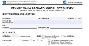
Front page of the PASS Form
important part of archaeology. While simply recording a site is much less glamorous and excited than actually getting to research and excavate a site, it does not mean it is any less important. Arguably, the recording without excavation is more important than the actual excavation. The State Historic Preservation Office manages the survey documentation and is in the process of creating a new online database called PAShare. This will eventually replace CRGIS. Both these databases house all the information about recorded sites. These sites can include large archaeological investigations to small isolated point finds. Regardless of their scale, they are all equally important. Information about possible sites can help to improve CRM investigations, identify locations for research and field schools, and improve predictive models.
Anyone can record a site. All the forms needed for any type of survey, record, or other investigation can be found on the PHMC’s website at https://www.phmc.pa.gov/Preservation/About/Pages/Forms-Guidance.aspx. The form specifically for site recording is the Pennsylvania Archaeological Site Survey (PASS) form. Most of the information in the form is regarding features, artifacts, and time periods present at the site. It can be used for historic sites, precontact sites, and multi-component sites. It also asks for information about the site’s location including slope, elevation, bedrock type, water locations and topographic setting. The environmental information allows for a better categorization of site types and locations.
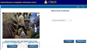
CRGIS search page
Not all the information provided in this form is given out to the general public. Contact information for the recorder and property owner is kept confidential. The exact Lat/Long location of the site is also confidential. One of the ethical responsibilities of SHPO and any archaeologist is to protect archaeological sites from looting. Providing exact locations to the general public could lead to looting or inexperienced, unauthorized excavations that harm the site’s integrity. Location information can be accessed by authorized personnel who are given permission by the SHPO. Contact information is left completely confidential so there is no worry about some annoying archaeologist contacting you and begging you to dig holes on your property.
For the property owner, there is no obligation or responsibility if a site has been recorded on your property. The SHPO and government will not limit your access or take away or property. It is only a recording of archaeological sites and will not impact a property owner’s use of the land. The recording only comes into play if a Section 106 and CRM survey is needed. In those cases, the record helps to guide survey analysis and project locations. The more sites that are recorded the more information can be provided for CRM work without having to go straight into the field. The only problem is that most of these sites are recorded as a result of CRM work and are only representative of areas that have been impacted by construction. The survey map is less of a map of sites and more a representation of urban expansion and construction. Some SPA groups such as the Westmoreland Archaeological Society have started to locate more sites and other groups such as the Carnegie Museum have been going through collections and old excavation reports to record new sites. As stated, anyone, not just professionals, archaeologists, or institutions, is able to record a site, so go forth and record.
Follow IUP Anthropology on Facebook, Twitter, and Instagram