Written by Savannah Weaver
 For my thesis project I will be surveying the Brush Valley Lutheran Church Cemetery in Indiana County, Pennsylvania. The Brush Valley Lutheran Church (BVLC) established the cemetery in the mid-19th century shortly after establishing the church. The BVLC property was privately owned by the church until the late 20th century. While the Lutheran congregation still rents the property for services, the cemetery is now used by the community as well as the congregation. The main goal of this thesis project is to analyze notable changes in headstone and burial patterns by comparing the privately owned section of the cemetery to the more publicly used section. Using geophysical methods and headstone analysis, surveys will be conducted over select areas within both sections of the cemetery. Comparative analysis based on the results from these surveys will indicate cultural and historical changes within the cemetery. Secondary goals of the project will be to determine if unmarked burials are present within the selected areas and if the headstones align with their designated burials. Few studies use headstone analysis and geophysical methods together when studying cemeteries. Most researchers use one method or the other. Integrating these two methods allows for more unique data and better interpretations of the cemetery. The results will also provide cultural and historical information about the cemetery and the community it is located in.
Headstone analysis and geophysics are the two methods by
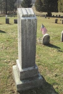
which surveys of the cemetery will be conducted. Headstone analysis examines the information on the headstone as well as size, shape, and materials used to craft it. This analysis allows researchers to examine the historical and cultural changes within a given community, such regional patterns, racial, economic, and societal influences on the formation of headstones. For this study, photographs of each of the headstones in selected sections of the cemetery will be taken and catalogued. The catalog will include the inscription, symbol, shape, size, and rock materials of each headstone. A Global Positioning System (GPS) unit will be used to capture data points of each photographed headstone and notable features within the cemetery, such as the chapel and fence line. The GPS data will be used to create a map of the cemetery to be compared against the data from the geophysical surveys.
Alongside headstone analysis geophysical methods will also be used because they provide non-invasive  means of collecting data. For this study, Ground Penetrating Radar (GPR) and Electrical Resistivity (ER) will be used. GPR will be able to identify grave shafts because of its ability to detect breaks or voids in the soil. GPR can also reach greater depths in the soil than other near surface geophysical methods as well as indicate size of the anomaly. The other geophysical method being used is ER which measures resistance soil and objects have to an electrical current. Resistance is measured by using electrical probes, spaced at various intervals. The greater the spacing the greater the depth the current will travel. ER can detect features and patterns below the ground surface. It is most successful at indicating stone, brick, cement, and highly compacted soils. Using ArGIS, maps of the GPR and ER data will be compared to each other to determine location of burials (known and unknown), changes in burial patterns, and the relationship between headstones and their designated burials. Changes in burial patterns could include orientation, shape, size, and depth. The use of headstone analysis and both GPR and ER will provide more comprehensive data and better interpretation of the cemetery and the cultural influences it reflects.
Follow IUP Anthropology on Facebook, Twitter, and Instagram