Written by Nathan Bokros

GPR survey to detect anomalies that could indicate the presence of the historic wagon shop
A field can hold much more than grass or corn. There can be much left on the surface or within the soil, like a projectile point, a foundation wall, and even a scatter of broken ceramics, all of which can reveal a story of past human experiences. My thesis focuses on a 19th century wagon making shop that was and still is located within a farmer’s field. The issue, however, is that there are no surface remains or scatter of artifacts on the surface that would indicate a wagon shop was once there. The family who lives on and near the property say that there used to be a wagon shop (or blacksmith shop) at a location in the field where there are three brown stones on the surface, which are said to be the foundation stones of the wagon shop.
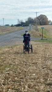
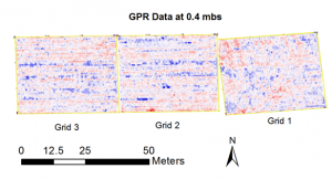
So now what? Should the who field be surveyed using shovel test pits (STPs)? Should only the area around the stones be excavated? What if the wagon shop was in another spot in the field or if the stones have been moved since the 1800s after the wagon shop closed down? My answer was to use ground penetrating radar (GPR) to survey the field within three 30 x 30 meter grids. The idea here is to see what is underground without having to dig STPs by using radar waves and a computer to note differences within the soil that may indicate places where potential features like foundation walls or hearths may be. Looking at the data collected by the GPR, see Figure 1, one can figure where it would likely be best to place a larger excavation unit based on patterns and unusual spots collectively referred to as anomalies. The use of GPR rather than STPs saves a lot of time and effort, which is very helpful when there is limited time and help in the midst of a global pandemic.

Results of the GPR survey
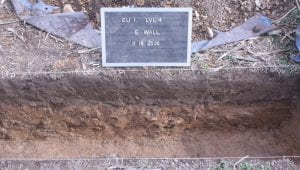
Based on the GPR data, three excavation units were planned with Excavation Unit 1 (EU 1) placed to bisect a strong circular anomaly found within the middle of Grid 1, EU 2 placed to bisect the rectangular anomaly found within the bottom right of Grid 1, and EU 3 placed where there was an unusual anomaly in the bottom left of Grid 1. Interestingly, no unusual anomalies were found in the ground near the surface stones. The other two grids had anomalies that were more reflective of the furrows made by plowing, so opening an excavation unit within those grids would not be helpful in finding the wagon shop. Two excavation units have been completed so far, though nothing that could be connected to the wagon shop has been uncovered, only a few pieces of modern refuse. Figure 2 shows the stratigraphy and the lack of features and artifacts of EU 1 that was characteristic of EU 2 as well. With one more excavation unit to go and a possible fourth excavation unit planned near the surface foundation stones, there is still a chance to find something related to the wagon shop or at least eliminate possible location for it.
Follow IUP Anthropology on Facebook, Twitter, and Instagram
