Gage Huey Thesis: Social Zooarchaeology At the Philo II Village

Written by Gage Huey

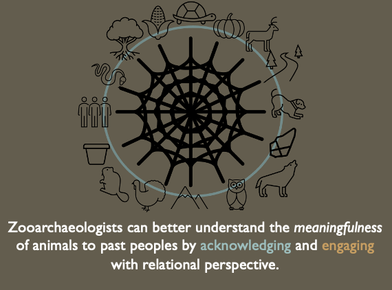
Zooarchaeology, or the study of animal remains in archaeological contexts has addressed the utilitarian aspects of human-animal interaction through decades of research on nutrition, seasonality, domestication, and the various techniques of carcass procurement and processing used by hunting cultures across the globe. As a result, traditional zooarchaeological interpretations rarely address the non-utilitarian meaningfulness of animals to the peoples whose material cultures we study. The way that archaeologists tend to think about human and animal relationships in the past typically reflects the structures and assumptions from our own worldview. These assumptions situate animals as an Other to humans, they serve our needs and can be used by humans but are fundamentally a different Thing. Over the centuries, these constructed differences between human beings and nature became more naturalized, fitting seamlessly into the colonial worldview that characterizes our “modern world”. Because scientific paradigms like anthropology were constructed within this worldview and the structures it produces. The interpretations we make as scientists reflect these as well. I believe this has led to misinterpretation of animal bones present at precontact sites through a largely Western perspective.

Indigenous peoples across the world (and specifically here on Turtle Island) see and saw the natural world in ways that would be incompatible with traditional zooarchaeological interpretation. So, my thesis research engages with an assemblage of animal remains through a perspective that acknowledges that prior to the arrival of Europeans (and continuing until today), Native peoples engaged with the environment not in terms of utilization, but in terms of relationships. The assemblage I’ve analyzed is from the 13th century (c.700 BP) Fort Ancient village,

Philo II (33MU76) located in Gaysport, Ohio. This village was constructed alongside an especially nice stretch of the Muskingum River known as the Philo Bottoms. This floodplain was home to Indigenous Ohioans for centuries, evidenced by the mound complex on the ridge overlooking

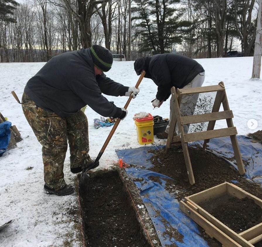
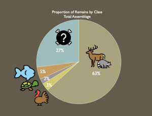
Philo II. These folks would’ve made pottery out of clay and mussel shells collected from the river, shared their pit-houses with dogs and stored maize, and hunted a variety of animals. The bones of these animals frequently ended up in subterranean “storage pits”, and vary in their number, species, and bone type (element) from feature to feature. Within the 55 features I analyzed, 27% of the bones were so fragmented they could only be reliably identified as indeterminate vertebrate. The remainder of the bones were identified to species when possible, but were broadly 63% mammal, 3% bird, 2% reptile, and 5% fish. The Philo Peoples would have had stories, songs, and all manner of cultural practices that engaged with these creatures not as animals in the Western sense, but as non-human persons that participated in society just as the humans did.

These relationships likely were not thought of in

an allegorical or metaphorical sense, they were a historical, lived reality. Imagine that a great ceremony was to be held in the plaza of Philo II, and the ceremony required music. The turtles whose shells were harvested to make instruments for the ceremony were taking part in the ceremony itself. In one sense, they were there (i.e., the turtles were plentiful) because they wanted to be there. And because the turtles had graciously attended the feast, there were particular cultural practices to ensure that they were honored and would continue to engage with the people in this way.

Through my research, I am arguing that the pit features at Philo II are physical manifestations of the intersocial relationships between humans and non-human animal persons. The construction of these features would have disposed of animal bone and provided a means of constructing and naturalizing the relationships present between the Philo Peoples and the animals in which they shared an environment. They may also have connections to cultural practices of memory-making, linking them to their Late Woodland ancestors who moved great amounts of earth to combine bones, sediments, and artifacts into highly meaningful spaces. If zooarchaeologists acknowledge and engage with Indigenous scholars and the perspectives they bring to the field, it would provide an opportunity for old collections to be re-interpreted and analyzed in a new light that more accurately reflects the cultural context of the peoples whose cultures we study.

Follow IUP Anthropology on Facebook, Twitter, and Instagram

Jamie Kouba Thesis: Bringing Archaeology into the 3-Dimesional Age

Written by Jamie Kouba

The most daunting part of earning your master’s degree has got to be picking a thesis topic.  After a year of anxiety-inducing ideas coming and going, I was talking to a second-year graduate student about technological advances in archaeology and something finally clicked.  As it turns out, there is a real need to establish digital repositories of 3D osteology comparative collections of both human and non-human specimens for researchers.  Digital comparative collections are a valuable resource for

Jamie taking photographs of a bone to make her 3D model

zooarchaeologists, bioarcheologists, osteologists, and non-specialists alike.  When a bone is recovered in the field, there are several questions that must be addressed immediately.  First, is it bone?  Second, is it human or animal.  Typically, a bone specialist is called in to make identifications, or someone accesses a physical comparative collection and hopefully identifies the unknown element.  However, an expert is not always available, and physical collections take up a lot of space, money, and time to maintain, limiting access to them.  One of the ways to supplement those issues is to reference a digital collection.  There are numerous websites out there, including Bone ID, Idaho Virtual Museum, and Sketchfab.  Different websites use different formats for how they display their specimens.  For instance, Bone ID provides 2D images, and Idaho Virtual Museum provides 3D scans, and Sketchfab is loaded with photogrammetric 3D models.  This thesis was born out of one question: are all of these digital references equal in their ability to provide identifications?


While doing research, I found that there was a lot of information on 2D references and 3D scanned references, but very little on the use of photogrammetry to create 3D models.  I had a feeling that 3D photogrammetric models would be the most effective form of digital reference. Photogrammetry uses a

The photogrammetry set up

series of photos to create photo-realistic 3D models.  An object is set on a rotating platform, and photos are taken all the way around it, from 3 different heights, then the object is rotated 180 degrees and the process is repeated.  This technique allows for a 360-degree view to create a 3D model with.  My thesis was designed to answer three research questions based on digital comparative collections: 1) Are photogrammetric 3D models useful in identifying osseous materials?  2) Can 3D models provide a more accurate identification than 2D photo references for osteological comparison?  3) Can 3D digital comparative specimens be used to supplement physical specimens that are not available?

In order to answer these questions, my thesis had several parts.  The first thing that I did was to create my own digital repository by creating 3D models using photogrammetry.  I made twenty models from the bones of bear, pig, cow, and human bone clones.  I also made a second digital repository of 2D images of those same bones.  Next, I designed a Qualtrics survey to test the efficacy of 2D/3D references.  I surveyed 20 people, half received 2D references, half received 3D references.  I would have preferred a larger sample, but the Covid-19 pandemic made it difficult to conduct these in person tests on a large scale.  When the surveys were finished, I ran a statistical analysis to see how effective each reference was in aiding faunal identification.  Along with the photogrammetry and survey parts of my thesis, I also analyzed a 3,600-element sample of faunal remains from Pocky Shell Ring in South Carolina.  I made notes during my identifications as to whether I used digital collections or physical collections to assist in making my identifications.

A 3D model created by Jamie

Upon starting this thesis, I assumed that the results of 2D references versus that of 3D photogrammetric references would be vastly different. What I discovered is that there are a lot of factors that can go into determining whether these references are effective.  These include the size and completeness of the element itself, whether the desired identification is of bone type, species, or which side it came from. All of my participants reported to having less than five years of experience identifying bones, so none of them were experts.  Overall people performed better on identifying bone type on a pig tibia, than they did on a bear metacarpal.  Yet those same people preformed much better on identifying that the metacarpal was from a bear, than that the tibia was from a pig.  What I can say for sure is that it appears that 3D photogrammetric references, on average, work as well as 2D references, with only about a 10% difference between them.  As for my own faunal analysis, I determined that when there are appropriate digital resources available, they are effective in helping to make the correct identification.  At the end of this, I feel that although more research is needed to confirm my results, photogrammetry can be used to create 3D digital references collections, which can be used to effectively identify unknown faunal remains.

Follow IUP Anthropology on Facebook, Twitter, and Instagram

Savannah Weaver Thesis: Investigation of the Brush Valley Lutheran Church Cemetery using Headstone and Geophysical Analysis


Written by Savannah Weaver

For my thesis project I will be surveying the Brush Valley Lutheran Church Cemetery in Indiana County, Pennsylvania. The Brush Valley Lutheran Church (BVLC) established the cemetery in the mid-19th century shortly after establishing the church. The BVLC property was privately owned by the church until the late 20th century. While the Lutheran congregation still rents the property for services, the cemetery is now used by the community as well as the congregation. The main goal of this thesis project is to analyze notable changes in headstone and burial patterns by comparing the privately owned section of the cemetery to the more publicly used section. Using geophysical methods and headstone analysis, surveys will be conducted over select areas within both sections of the cemetery. Comparative analysis based on the results from these surveys will indicate cultural and historical changes within the cemetery. Secondary goals of the project will be to determine if unmarked burials are present within the selected areas and if the headstones align with their designated burials. Few studies use headstone analysis and geophysical methods together when studying cemeteries. Most researchers use one method or the other. Integrating these two methods allows for more unique data and better interpretations of the cemetery. The results will also provide cultural and historical information about the cemetery and the community it is located in.

Headstone analysis and geophysics are the two methods by

which surveys of the cemetery will be conducted. Headstone analysis examines the information on the headstone as well as size, shape, and materials used to craft it. This analysis allows researchers to examine the historical and cultural changes within a given community, such regional patterns, racial, economic, and societal influences on the formation of headstones. For this study, photographs of each of the headstones in selected sections of the cemetery will be taken and catalogued. The catalog will include the inscription, symbol, shape, size, and rock materials of each headstone. A Global Positioning System (GPS) unit will be used to capture data points of each photographed headstone and notable features within the cemetery, such as the chapel and fence line. The GPS data will be used to create a map of the cemetery to be compared against the data from the geophysical surveys.

Alongside headstone analysis geophysical methods will also be used because they provide non-invasive means of collecting data. For this study, Ground Penetrating Radar (GPR) and Electrical Resistivity (ER) will be used. GPR will be able to identify grave shafts because of its ability to detect breaks or voids in the soil. GPR can also reach greater depths in the soil than other near surface geophysical methods as well as indicate size of the anomaly. The other geophysical method being used is ER which measures resistance soil and objects have to an electrical current. Resistance is measured by using electrical probes, spaced at various intervals. The greater the spacing the greater the depth the current will travel. ER can detect features and patterns below the ground surface. It is most successful at indicating stone, brick, cement, and highly compacted soils. Using ArGIS, maps of the GPR and ER data will be compared to each other to determine location of burials (known and unknown), changes in burial patterns, and the relationship between headstones and their designated burials. Changes in burial patterns could include orientation, shape, size, and depth. The use of headstone analysis and both GPR and ER will provide more comprehensive data and better interpretation of the cemetery and the cultural influences it reflects.


Follow IUP Anthropology on Facebook, Twitter, and Instagram

Brendan Cole Thesis: An Exploration of New Techniques

Written by Brendan Cole

The Monongahela Cultural Tradition is recognized as dating to the Late Prehistoric period, approximately A.D. 1150 to 1635. Additionally, it is identified as being present in southwestern Pennsylvania, eastern Ohio, and northern West Virginia, where they lived in stockaded farming villages. The Monongahela culture was present during initial European contact, but there is currently no evidence that they were directly contacted by Europeans and were gone by the time settlers had reached Western Pennsylvania. The site used in this study is a Monongahela village site known as Squirrel Hill. It is a village site located in Westmoreland County. While the site was discovered in the mid-20th and there have been subsequent thesis studies and field schools conducted, there is still much unknown about the site.

Soil pellet creator

The focus of this thesis is to explore the efficacy of non-invasive archaeological techniques to extract archaeological data. It is important to explore non-invasive/destructive methodologies because traditional archaeological excavation techniques are destructive in nature. Essentially whatever we dig up is removed from its original context, thus destroying that portion of the site. Preservation ethic, in short, tells us that if we do not need to excavate a site we should not. This not only preserves a non-renewable resource but saves them for the future when new excavation techniques, technologies, and research questions are developed.

Portable XRF device in workbench setup

Currently, there are technologies available to us that allow for data extraction without site disturbance or destruction. Two of those techniques, and the ones used in this thesis study, are ground-penetrating radar (GPR) and x-ray fluorescence (XRF). Separately these techniques have been proven to have great utility, but they have scarcely been used together.

This study aims to use both techniques in tandem at the Squirrel hill site. The GPR data will be overlain with elemental density maps constructed from the XRF. The primary goal of this will be to see where GPR anomalies and XRF elemental data overlap and where it does not. This will show areas of cultural activity and suggest what activities were occurring in those places. By doing this we will also gain an idea of village layout. All this information will not only help guide future research questions and excavation at the site, but it may also show the efficacy of using these methods together at other sites.


Follow IUP Anthropology on Facebook, Twitter, and Instagram

Jesse Metzler Thesis: A Multi Property Documentation Form for Underground Railroad Resources in Indiana County

Written by Jesse Metzler

A fascinating aspect of the history of Indiana County is its link to the Underground Railroad. Individuals interested in history have likely noticed the PA Historical Markers scattered around Indiana County that describe the anti-slavery efforts of the population. One such marker is situated near the corner of Philadelphia Street and South Sixth Street and tells Anthony Hollingsworth’s story. Hollingsworth was one of the known freedom seekers who traveled through Indiana and was the victim of a kidnapping by bounty hunters. Hollingsworth ultimately received legal assistance from the abolitionists of Indiana and eventually settled in Canada.

The Indiana Courthouse circa 1856, the site of the Hollingsworth’s kidnapping trial. Source- Blairsville Area Underground Railroad 2021

There are Underground Railroad sites dispersed across Indiana and Blairsville, including historic buildings and potential archaeological sites. However, there is no definitive inventory of Underground Railroad related properties in Indiana County. The impetus for this thesis was an interest in researching a viable method for recording and preserving a delicate portion of the historical record.  This thesis examines the utility of the National Register Multi Property Documentation Form (MPDF) as a tool for preserving Underground Railroad resources in Indiana County by analyzing three case studies. These case studies are based on MPDFS submitted for Underground Railroad resources in three states: Massachusetts, New York, and Ohio. Examining the MPDFs for these states indicates that cultural resource professionals can utilize them to identify and document Underground Railroad sites.

This thesis’s field component focuses on a historic property

An interpretative sign describing the life of John Graff. The marker is a part of the Blairsville Area Underground Railroad’s driving tour.

in Blairsville linked to the Underground Railroad. The John Graff House was constructed for John Graff during the early nineteenth century. Graff was a prominent entrepreneur, politician, and philanthropist who held abolitionist ideals.  Graff was one of the reported abolitionists of Indiana County who reportedly assisted individuals that utilized the Underground Railroad. Local history suggests that Graff constructed a tunnel under his property that ran to the bank of the Conemaugh River, allowing for discrete travel in and out of Blairsville.  The Graff Property was the subject of a Historic Resource Survey Form (HRSF), which included an architectural survey of the house. A ground penetrating radar (GPR) survey was conducted to ascertain the presence of a tunnel on the property. The HRSF was intended to serve two functions, including the documentation of a known Underground Railroad related property and a potential starting point for developing an MPDF for Underground Railroad resources in western Pennsylvania.  MPDFs offer CRM practitioners the ability to develop a framework for identifying and documenting historic properties and archaeological sites. There is considerable potential for an MPDF to aid in preserving the Underground Railroad resources of Indiana County.

Follow IUP Anthropology on Facebook, Twitter, and Instagram

Nathan Bokros Thesis: Investigating a Wagon Shop

Written by Nathan Bokros

GPR survey to detect anomalies that could indicate the presence of the historic wagon shop

A field can hold much more than grass or corn. There can be much left on the surface or within the soil, like a projectile point, a foundation wall, and even a scatter of broken ceramics, all of which can reveal a story of past human experiences. My thesis focuses on a 19th century wagon making shop that was and still is located within a farmer’s field. The issue, however, is that there are no surface remains or scatter of artifacts on the surface that would indicate a wagon shop was once there. The family who lives on and near the property say that there used to be a wagon shop (or blacksmith shop) at a location in the field where there are three brown stones on the surface, which are said to be the foundation stones of the wagon shop.

So now what? Should the who field be surveyed using shovel test pits (STPs)? Should only the area around the stones be excavated? What if the wagon shop was in another spot in the field or if the stones have been moved since the 1800s after the wagon shop closed down? My answer was to use ground penetrating radar (GPR) to survey the field within three 30 x 30 meter grids. The idea here is to see what is underground without having to dig STPs by using radar waves and a computer to note differences within the soil that may indicate places where potential features like foundation walls or hearths may be. Looking at the data collected by the GPR, see Figure 1, one can figure where it would likely be best to place a larger excavation unit based on patterns and unusual spots collectively referred to as anomalies. The use of GPR rather than STPs saves a lot of time and effort, which is very helpful when there is limited time and help in the midst of a global pandemic.

Results of the GPR survey

Excavation Unit 1 wall showing stratigraphy

Based on the GPR data, three excavation units were planned with Excavation Unit 1 (EU 1) placed to bisect a strong circular anomaly found within the middle of Grid 1, EU 2 placed to bisect the rectangular anomaly found within the bottom right of Grid 1, and EU 3 placed where there was an unusual anomaly in the bottom left of Grid 1. Interestingly, no unusual anomalies were found in the ground near the surface stones. The other two grids had anomalies that were more reflective of the furrows made by plowing, so opening an excavation unit within those grids would not be helpful in finding the wagon shop. Two excavation units have been completed so far, though nothing that could be connected to the wagon shop has been uncovered, only a few pieces of modern refuse. Figure 2 shows the stratigraphy and the lack of features and artifacts of EU 1 that was characteristic of EU 2 as well. With one more excavation unit to go and a possible fourth excavation unit planned near the surface foundation stones, there is still a chance to find something related to the wagon shop or at least eliminate possible location for it.

Follow IUP Anthropology on Facebook, Twitter, and Instagram

Angela Rooker Thesis: Geophyte Use and HPRCSITs on the Malheur National Forest, Oregon

Written by Angela Rooker

Malheur National Forest

Ever since I started working as a seasonal archaeological technician on the Malheur National Forest in eastern Oregon, I’ve been fascinated by the diversity of plant life in this extraordinary desert. So it was only natural to pick a thesis topic related to precontact plant use. Working for a National Forest and other public archaeology experiences also got me interested in finding ways to share the knowledge gained in ways that are meaningful to the local and descendant communities. I was able to roll both of these interests together into a two-part thesis. First it will create a precontact context for geophyte use on the Malheur National Forest and thus add to the understanding of geophyte utilization in eastern Oregon. Second, it will propose a management plan for geophytes on the Malheur National Forest as well as better ways to manage Historic Properties of Religious and Cultural Significance to Indian Tribes (HPRCSIT)s and Traditional Cultural Properties.

Geophytes, such as camas and Lomatium, are plants with edible, underground, storage organs (ie roots, rhizomes, and tubers), and have been important in the diets of the American Indians living in the Pacific Northwest for thousands of years. Among the most

Apiaceae Plant

commonly utilized geophytes were common camas (Camassia quamash), wild carrot/yampa (Perideridia gairdneri), Lomatium (Lomatium sp.), umbellifers/parsley family (Apiacae), bitterroot (Lewisia rediviva), balsamroot (Balsamorhiza sp.) and wild onion (Allium sp.). Geophytes are major sources of carbohydrates, but also provide protein, vitamins, and minerals depending on the species. Inulin, the major carbohydrate in camas, onions and balsamroot and to a lesser extents Lomatium is largely indigestible until cooked. Traditionally, many geophytes were processed on hopper mortars and then cooked in earth ovens, features still visible on the landscape today and protected as cultural resources. Geophyte use is most prevalent on the Columbia Plateau and portions of the northern Great Basin that border the Columbia Plateau. However, many studies only examine the Plateau or the Great Basin (Fowler and Rhodes 2006 and Cummings 2004).

Camas Plan

This can make it hard to determine the diet of people that lived in between the Great Basin and the Columbia Plateau, including the area that now encompasses the Malheur National Forest. Furthermore, geophytes themselves generally do not preserve well in the archaeological record, so much of the evidence relating to their use is inferred by the presence of digging sticks, hopper mortars, other grinding and pounding tools (including grinding slabs and pestles), earth ovens, storage pits, and upper-elevation base camps (Lepofsky 2004:426-427; Lepofsky and Peacock 2004:130). Modern descendants are not as dependent on wild foodstuffs as their ancestors,

Bitterroot Plant

yet traditional foods, especially plant foods, remain meaningful as delicacies and as touchstones of Native identity (Soucie 2007:57-59; Aikens and Couture 2007:278-279). For example, land owned by the Burns Paiute Tribe contains the Biscuit Root Area of Critical Environmental Concern, a 6,500 acre preserve of a traditional root gathering area (Soucie 2007:57).  The Confederated Tribes of the Umatilla American Indian Nation has the “First Foods” program; the Confederated Tribes of Warm Springs has four yearly feasts (the Root Feasts, The First Catch, The Huckleberry Feast, and the Celery Feast), all of which are used to educate and connect tribal members with traditional foods.


Second, this thesis explores “Historic Property of Religious and Cultural Significance to Indian Tribes” (HPRCSIT), one of the property designations identified as part of the legal mandate established by National Environmental Policy Act (NEPA) and Section 106 of the National Historic Preservation Act (NHPA) that requires federal agencies (or those utilizing federal money, working on federal land, requiring a federal permit, or preforming actions subject to federal oversight) to consider the effects of

Hopper Mortar


their actions on natural and cultural resources. HPRCSIT is a recent designation, first appearing around 2016. It came about to offer American Indians more control over actions that affect sacred sites and other places important to their contemporary cultural practices (Donn Hann, personal communication 2019). American Indian Nations are hopeful that the HPRCSIT designation will offer greater legal protection because it takes language directly from 36CFR800.2(D), namely the phrase “Federal agencies should be aware that frequently historic properties of religious and cultural significance are located on ancestral, aboriginal, or ceded lands of Indian tribes and Native Hawaiian organizations and should consider that when complying with the procedures in this part,” (emphasis added). I hope this project will provide an example of combining academic research and management practices to find the best balance between cultural heritage and the other activities on public lands, such as recreation, thinning and timber harvesting, cattle grazing, and prescribed fire.


Follow IUP Anthropology on Facebook, Twitter, and Instagram


An Analysis of Chert Usage from the Squirrel Hill Site (36WM35) – Thesis by Zac Fischer

Written by Zac Fischer,

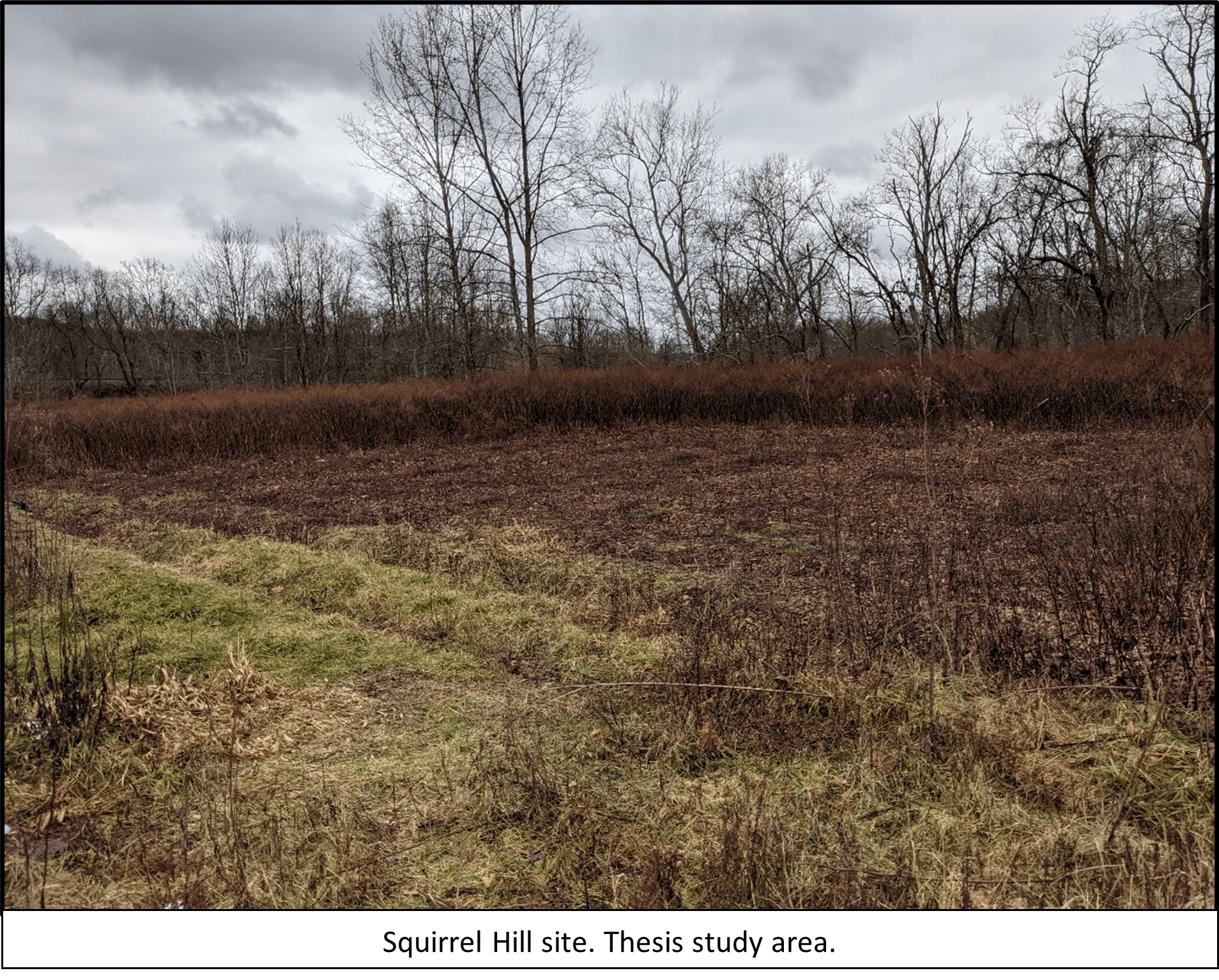
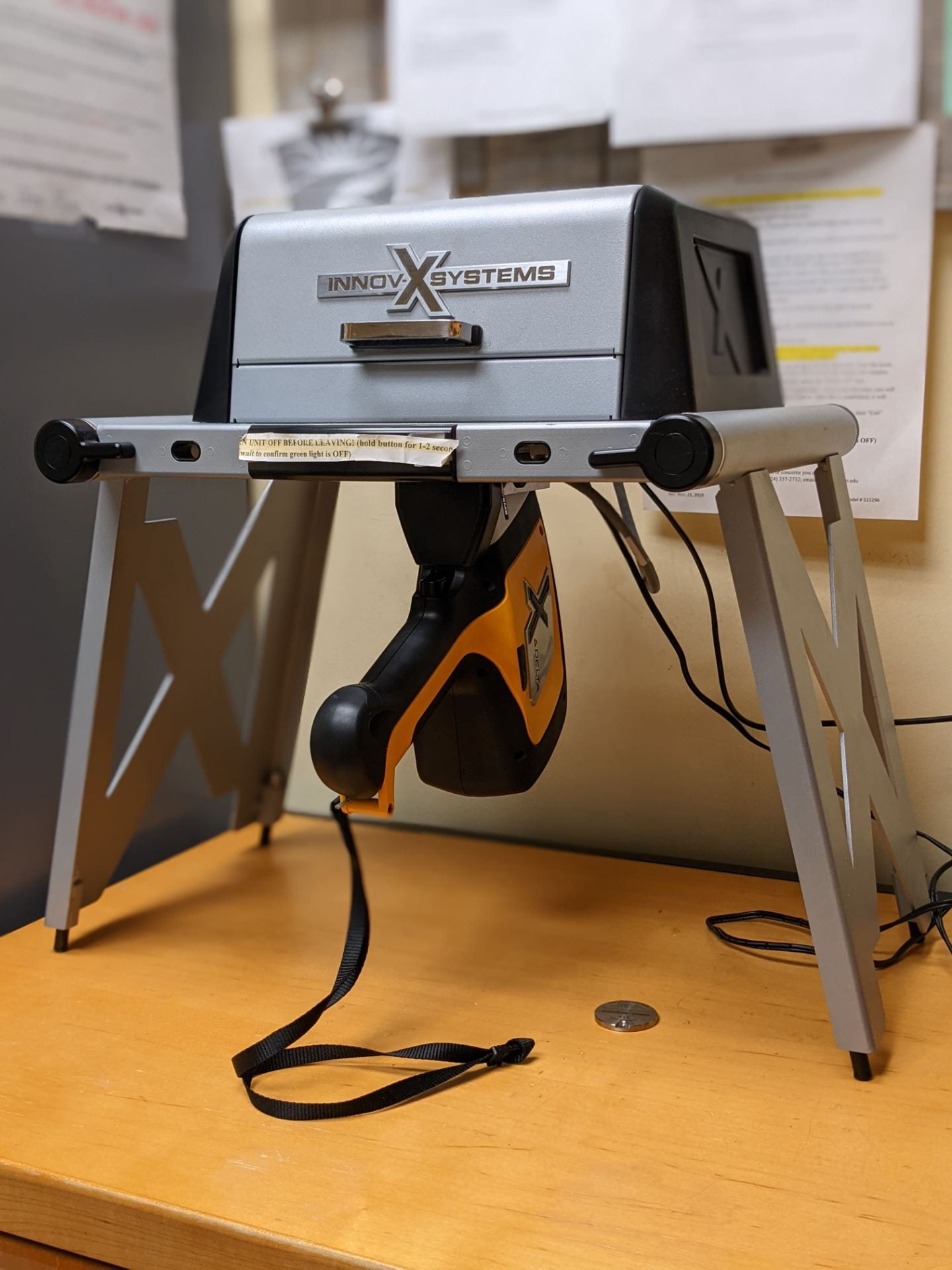
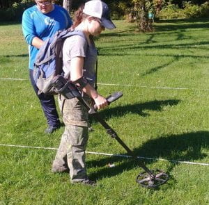
My thesis research focuses around the Squirrel Hill site, a Johnston phase (1450-1590AD) Monongahela village near New Florence, PA.  More specifically, this research focuses on the debitage and specific cherts found at the site.  For those less familiar with the jargon, I’m looking at the specific types of stones that would be used to produce tools and the chipped fragments of that stone.  What I want to know can be summed up in three questions.  First, do different chert types have different chemical signatures or fingerprints?  Second, what chert types are present at Squirrel Hill and where are they coming from?  Are the cherts local and thus sourced by the Monongahela or are there also non-local cherts which could be representative of interaction such as trade with other cultural groups.  Third, if multiple chert types are present, do they spatially segregate between the typical Monongahela domestic structure and the anomalous rectangular structure at the site? To answer these questions my research methods can be broken into two main points: chemically examining chert types to try and produce a chemical fingerprint; comparing the chert types and debitage from Squirrel Hill to the Johnston site (another Johnston phase Monongahela village), comparing across the site, and comparing between traditional domestic structures and an anomalous rectangular structure at the site.

A portion of my thesis hinges on our department’s portable X-Ray Fluorescence (pXRF) device.  PXRF is a non-destructive analytical tool that measures chemical composition by directing x-rays at a sample.  This causes your sample to emit energy at specific energies and wavelengths that are characteristic of its elemental components.  The device detects the specifics and measures the different components in parts per million.  From the chemical data that I am collecting through this method, I will attempt to produce a chemical signature or fingerprint for cherts accessible to the Monongahela tradition.  Similar studies have occurred with varying degrees of success, so this may or may not work.  If it does work, the chemical fingerprints should help in analyzing chert types of debitage from Squirrel Hill and potentially other Monongahela sites.  How would this help?  In the case of debitage from Squirrel Hill, most lithic flakes are tertiary, presumably from late stage tool production or tool sharpening and reworking.  In other words, these flakes are very small and cherts accessible by the Monongahela at Squirrel Hill can be easily confused due to similar colors and textures.  Having less material makes it somewhat more difficult to correctly identify cherts.  So, if we could chemically examine flakes that are unable to be identified otherwise and compare the data to chemical fingerprints, we could potentially identify the chert type.  If a chert does not match with any of the fingerprints, then it could be suggested that it came from a non-local source.  The presence of such cherts could be representative of interaction with other cultural groups like through trade.

Even if my chemical analysis does not go as planned, I will still be examining chert types and debitage from Squirrel Hill.  Again, I plan on comparing at the intersite and intrasite levels.  I’m comparing the debitage between Squirrel Hill and the Johnston site to look at variation in chert usage within Johnston phase sites.  Knowing the difference in chert usage between sites of the same temporal, regional, and cultural affiliation should help guide my interpretations of later comparisons.  Next, I would compare across Squirrel Hill, for example the northern and southern portions of the site, to see how chert usage varies at the site in a more general sense. Finally, the comparison takes another look at the site by comparing between typical domestic structures and the unusual rectangular structure.  Why am I concerned about this rectangular thing?  Well, it’s out of the ordinary for Monongahela sites.  How out of the ordinary?  A typical Monongahela domestic structure is round and about 3-4m in diameter, but they have been known to be upwards of 6m in diameter (Dragoo 1955).  The anomaly is about 6-7m wide and 35m long.  Why is it at the site?  We don’t truly know, but it has been hypothesized that the unusual nature of the structure could be representative of interaction with or habitation by another cultural group.  Ultimately, I hope that my analysis will bring us a step closer to understanding who occupied that structure by examining the cultural material within.


Dragoo, Don

1955    Excavations at the Johnston Site, Indiana County, Pennsylvania. Pennsylvania Archaeologist 25(2) 85-141.

Follow IUP Anthropology on Facebook, Twitter, and Instagram

Janee Becker Thesis Project: Archaeological Investigation at the Wigwam

Written by Janee Becker

My thesis research focuses on archaeological investigations at The Wigwam in Dubois, PA. The Wigwam Project investigates the historic context and potential significance of 20th-century Native American performer campsites in western Pennsylvania. The Wigwam is the former home of Major Israel McCreight, a prominent historical figure in local Dubois history. The property was built in 1906 and has historically been documented as a camp for Buffalo Bill’s Wild West Show, a haven for visiting Native Americans, and the location of a Six Nations Mowhawk tribe council house. Aside from Buffalo Bill Cody, Major Israel McCreight often hosted chiefs Flying Hawk and Iron Tail and was considered a life-long friend and defender of Native Americans.

No previous cultural resource investigations have been conducted within the vicinity of the Wigwam property. Therefore, this project attempts to locate features related to historic Native American performer campsites using metal detector and geophysical survey in the form of magnetic gradiometer survey. Archaeological investigations of these deposits excavated approximately four and a half square meters. These investigations recovered approximately 870 artifacts including charcoal, lithic debitage, and a piece of worked glass potentially associated with historic Native American short-term use of the site.

Classical research into the historic assimilation of Native Americans often focuses on the dichotomy of change and continuity from precontact cultural practices to European colonialism (Silliman 2009). Therefore, it often obscures the use of Euro-American materials by Native Americans to represent their own cultural heritage; creating a narrative of Native American authenticity (Cipolla 2013b). This belief in authenticity implies that to be a true Native American, the cultural lifeways and materials must reflect precontact cultural practices. Silliman (2009:212) rightly questions the appropriateness of using these “precontact cultural practices as the baseline” in archaeological research.

Photo by Jamie Kouba

Data collected through these investigations attempt to address the adaption and resiliency of Native American’s during the period of 1906 through 1913. Research questions will explore the pressures of this time-period on Native American lifeways and how these pressures influenced Native American performer identity. These investigations are a study of archaeological materials associated with the with these changing identities.


Follow IUP Anthropology on Facebook, Instagram, and Twitter

Zaakiyah Cua Thesis Defense: Loyalhanna Creek Geophysical Analysis

Today January 24, 2020 one of our graduate students defended her thesis.  Zaakiyah Cua graduated from her undergrad at Youngtown State University with degrees in Anthropology and Geography and a GIS Certificate in 2015.  In 2018 she received the Paul Goldberg Award at the SAA conference for her work using Earth Science methods in archaeology.  Zaakiyah’s thesis is entitled Loyalhanna Creek: A Geoarchaeological Approach to Understanding the Archaeological Potential of Floodplains.  Loyalhanna Creek is a point bar of upstream of a dam in Westmoreland County, PA.  Her research used ground penetrating radar, gradiometry, and auger sampling to find anomalies and investigate soil horizons.  As in all IUP graduate theses, Zaakiyah’s research was directed by three research questions. They are:

-Are there Buried Landscapes that have the potential to yield pre-contact archaeological sites within the selected floodplain along the Loyalhanna Creek?

-If there are buried landscapes what are the extent of these landscapes, how do they relate to one another, and what was the landscape before sediment deposition?

-What is the Archaeological potential of existing buried landscapes on the selected floodplain?

Zaakiyah first surveyed her area using GPR and gradiometry in order to answer questions one and locate possible buried landscapes.  After analyzing her data and comparing both geophysical methods to each other and topographic maps, she located 6 potential large landscapes.  She augured select points along these landscapes to compare the landscape horizons.  The soil samples were first analyzed in the field using visual characteristics and then in the lab using particle size analysis.  Using these methods, she was able to identify several soil trends including stacked B horizons, buried A horizons, and restricting features within a landscape.  One landscape had enough charcoal deposits to conduct radiocarbon dating providing her with a date of roughly 5000 BP for that horizon.  From all of this data, Zaakiyah was able to show that there is archaeological potential for that area and recommends more research and sampling.

She gave an amazing and very professional presentation to her research committee and around 8 current graduate students.  One professor commented that her research is one of the most impressive to come out of the program in many years.  She spent a total of four years surveying, analyzing, and writing her thesis.  Everyone was very impressed with the amount of work she was able to accomplish in that short time.  The department is very proud of her and wishes her the best in her future careers.

To learn more about IUP’s graduate and undergraduate opportunities visit https://www.iup.edu/anthropology/

Also follow us on Facebook, Twitter, and Instagram